This is the Metadyne Website
The Metropolitan District Railway Large Format Maps
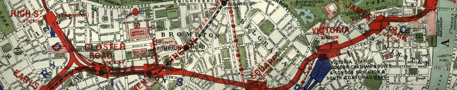
District Railway Maps
The Metropolitan District Railway (1868-1933) was the second of London's Underground railways and is now the basis of today's District Line.
It was by no means unique in publishing maps of its system, most railways did that in one form or another. It is unusual in the variety of different types of map it produced and that it continued to do so for almost the whole of its independent existence and (in the case of its miniature map) for some years longer.
The large format maps were published mainly in the last quarter of the nineteenth century and the first few years of the twentieth. They could be obtained flat or folded within cloth or card covers, or varnished between rollers. They were produced in full colour on a quite detailed base map showing nearly all the streets. Attractive and desirable as artifacts, a map less suited to planning a public transport journey is hard to imagine.
These are the earliest series of maps produced for London Underground's passengers. The maps are fascinating but exist in a large number of different states.
Any comments, or additional information, will be especially welcome.
This treatise has attempted to publish all that is known about the different states. It is partly based on a number of published but not widely known sources (mainly Garnett and Hyde), and partly on the author's collection or those of his colleagues.
Any errors or omissions that readers may care to point out would be most helpful.
Download article
To download the article about District maps please click the button below. Please give the above download several seconds to arrive as it is at least a large-ish file. If you experience a problem using the button, there is an alternative link at the bottom of the column. You may find it helpful to avoid Google Chrome, which I have found to be troublesome with pdf files.